South Britain Historic District Commission
|
Description of the South Britain District
 The following was excerpted from “Proposed Historic District for the Village of South Britain” a document published by the South Britain Historic District Study Commission in March of 1989:
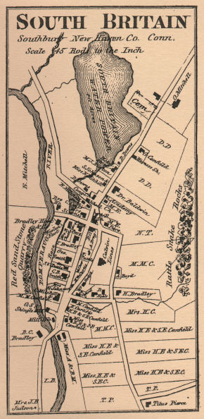
“The Village of South Britain stands as a legacy of the past and is a unique example of historic significance to the town of Southbury. Recognizing this the Federal Government approved the village for listing in the National Register of Historic Places in 1986.
South Britain was settled in the early 18th century, providing services to support the surrounding agricultural community. A dam at the rapids of the Pomperaug River supplied water power for a variety of milling operations. Industrial activities increased during the 18th century and the first half of the 19th, but declined after the Civil War.
Fortunately, South Britain retains and reflects much of its past appearance and character with a predominance of 18th and 19th century structures. Although no longer straddling a dirt road fringed with stately maple trees, South Britain was, and remains, a semi-rural self-contained community.
The Village is fairly isolated, being bordered on the east by steep wooded ridges and on the west by the picturesque Pomperaug River and an open, undeveloped flood plain. In general, these natural features have been followed to establish the boundaries for the proposed South Britain Historic District.”
A copy of the source document, which contains photographs of all of the structures in the District, is available from the Commission free to South Britain Historic District property owners, and is for sale to anyone by the Southbury Historical Society.